
General Information on the Union of Myanmar
1. Geographical Location and Strategic Setting
The Union of Myanmar lies at the north-western edge of mainland Southeast Asia, occupying a unique and strategic position between South Asia and Southeast Asia. It is bordered by the People’s Republic of China to the north and northeast, Laos to the east, Thailand to the southeast, Bangladesh to the west and the Republic of India to the northwest.
This location places Myanmar — sandwiched between two of the world’s most populous nations, China and India — in a geopolitically and economically significant corridor.
The country shares the following approximate border lengths:
China: 2,192 km (1,362 miles)
India: 1,331 km (827 miles)
Bangladesh: 256 km (157 miles)
Thailand: 2,096 km (1,302 miles)
Laos: 224 km (139 miles)
Coastline: 2,276 km (1,414 miles)
Topographically, Myanmar features major mountain chains in the north and west, vast lowland river valleys (notably the Irrawaddy/Ayeyarwady), and coastal plains extending to the Andaman Sea and Bay of Bengal. Encyclopedia Britannica+1
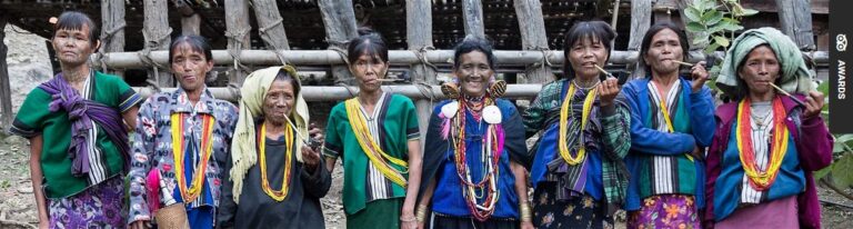
2. People, Ethnicity and Religion
Myanmar is home to eight major national ethnic races and an estimated 135 distinct ethnic groups. The eight principal races are:
Kachin
Kayin (Karen)
Kayah
Chin
Mon
Bamar
Rakhine
Shan
Among these, the Bamar (also referred to as “Burman” historically) constitute approximately 70% of the entire population.
In religious composition, the vast majority of Myanmar’s people (approximately 89.2%) practice Buddhism, while smaller communities follow Christianity, Islam, Hinduism, Judaism and Animist traditions.
Detailed list of 135 ethnic groups in Myanmar.
(1) Kachin
(2) Trone
(3) Dalaung
(4) Jinghpaw
(5) Guari
(6) Hkahku
(7) Duleng
(8) Maru (Lawgore)
(9) Rawang
(10) Lashi (La Chit)
(11) Atsi
(12) Lisu
(B) Kayah comprises 9 different ethnic groups.
(13) Kayah
(14) Zayein
(15)Ka-Yun (Padaung)
(16) Gheko
(17) Kebar
(18) Bre (Ka-Yaw)
(19) Manu Manaw
(20) Yin Talai
(21) Yin Baw
(C) Kayin comprises 11 different ethnic groups.
(22) Kayin
(23) Kayinpyu
(24) Pa-Le-Chi
(25) Mon Kayin (Sarpyu)
(26) Sgaw
(27) Ta-Lay-Pwa
(28) Paku(29) Bwe
(30) Monnepwa
(31) Monpwa
(32) Shu (Pwo)
(D) Chin comprises 53 different ethnic groups.
(33) Chin
(34) Meithei (Kathe)
(35) Saline
(36) Ka-Lin-Kaw (Lushay)
(37) Khami
(38) Awa Khami
(39) Khawno
(40) Kaungso
(41) Kaung Saing Chin
(42) Kwelshin
(43) Kwangli (Sim)
(44) Gunte (Lyente)
(45) Gwete
(46) Ngorn
(47) Zizan
(48) Sentang
(49) Saing Zan
(50) Za-How
(51) Zotung
(52) ZO-Pe
(53) Zo
(54) Zahnyet (Zanniet)
(55) Tapong
(56) Tiddim (Hai-Dim)
(57) Tay-Zan
(58) Taishon
(59) Thado
(60) Torr
(61) Dim
(62) Dai (Yindu)
(63) Naga
(64) Tanghkul
(65) Malin
(66) Panun
(67) Magun
(68) Matu
(69) Miram (Mara)
(70) Mi-er
(71) Mgan
(72) Lushei (Lushay)
(73) Laymyo
(74) Lyente
(75) Lawhtu
(76) Lai
(77) Laizao
(78) Wakim (Mro)
(79) Haulngo
(80) Anu
(81) Anun
(82) Oo-Pu
(83) Lhinbu
(84) Asho (Plain)
(85) Rongtu
(E) Bamar comprises 9 ethnic groups.
(86) Bamar
(87) Dawei
(88) Beik
(89) Yaw
(90) Yabein
(91) Kadu
(92) Ganan
(93) Salon
(94) Hpon
(F) Mon comprises 1 ethnic groups.
(95) Mon
(G) Rakhine comprises 7 ethnic groups.
(96) Rakhine
(97) Kamein
(98) Kwe Myi
(99) Daingnet
(100) Maramagyi
(101) Mro
(102) Thet
(H) Shan comprises 33 ethnic groups.
(103) Shan
(104) Yun (Lao)
(105) Kwi
(106) Pyin
(107) Yao
(108) Danaw
(109) Pale
(110) En
(111) Son
(112) Khamu
(113) Kaw (Akha-E-Kaw)
(114) Kokang
(115) Khamti Shan
(116) Hkun
(117) Taungyo
(118) Danu
(119) Palaung
(120) Man Zi
(121) Yin Kya
(122) Yin Net
(123) Shan Gale
(124) Shan Gyi
(125) Lahu
(126) Intha
(127) Eik-swair
(128) Pa-O
(129) Tai-Loi
(130) Tai-Lem
(131) Tai-Lon
(132) Tai-Lay
(133) Maingtha
(134) Maw Shan
(135) Wa
3. Pre-Independence Era
During the colonial era, the British applied a “divide and rule” policy in Burma (now Myanmar), which laid the groundwork for fragility in national unity at the moment of independence. Prior to full self-rule, a variety of ideologies – nationalist, socialist, ethnic – had already begun to proliferate among those fighting colonial rule.
A pivotal moment occurred on July 19, 1947, when General Aung San and his cabinet ministers were assassinated, an act considered among the most detrimental in the country’s history. It left the country almost leaderless at the moment of independence (January 4, 1948).
Additionally, under British rule, opium-production was introduced forcibly into northern Myanmar states in the 19th century, as part of expansion of the opium trade with China — a legacy that continues to generate challenges for Myanmar to this day.
4. The Name Debate: “Myanmar” or “Burma”
The change of the country’s official English name from “Burma” to “Myanmar” (in 1989) remains a subject of emotional and political significance for many. While some politicians continue to use “Burma” for historic or political reasons, large segments of the population regard the use of “Myanmar” as a rightful restoration of the country’s authentic name.
It is important to note that “Myanmar” and its capital “Yangon” are not recent creations of the 1989 government: they are the original names used in the Burmese language, which the British colonial administration rendered as “Burma” and “Rangoon.”
The State Law and Order Restoration Council (SLORC) formally reinstated the names with two main purposes: to release the country psychologically from its colonial past and to foster a sense of national unity under the banner of the “Union of Myanmar.”
In the absence of reinstatement by successive governments until then, the name-change remains a symbolic act of national identity. Since the United Nations recognises the country by “Myanmar”, it can be argued that international acceptance is now the de jure standard.
5. Post-Independence Insurgency and Internal Challenges
Following independence in 1948, the newly formed civilian government pursued a parliamentary democracy. However, internal party rivalries, neglect of ethnic minority concerns, and political manoeuvring for election support triggered rebellion among various ethnic groups.
A stark example: the then-Prime Minister proclaimed Buddhism as the state religion to secure votes from the Buddhist majority, at the same time overlooking the aspirations of ethnic minorities of other faiths. This exacerbated ethnic tensions and paved the way for armed insurgency. The military, whether by design or default, became involved in these conflicts. Some of those conflicts lasted for decades.
6. Foreign Policy of Myanmar
From its independence, Myanmar adopted an independent foreign policy, initially joining but later departing the British Commonwealth, and during the Cold War era, adopting a strongly non-aligned stance. The advantages of this approach included remaining outside many regional conflicts. The downside: Myanmar developed neither strong capitalist alliances nor deep ties with the communist bloc.
During its socialist era (1962–1988), Western countries regarded Myanmar as a de-facto communist state, while socialist states saw it as a pseudo-socialist country. While largely self-isolating, Myanmar avoided deep entanglements, choosing instead to define its path according to national interests.
Frequently Asked Questions (FAQ) About Myanmar
1. Where is Myanmar located?
Myanmar is located in Southeast Asia, bordered by China to the north and northeast, Laos to the east, Thailand to the southeast, Bangladesh to the west, and India to the northwest. It also has a long coastline along the Andaman Sea and the Bay of Bengal.
2. What is the capital of Myanmar?
The official capital of Myanmar is Nay Pyi Taw, while Yangon remains the country’s largest city and main commercial center.
3. How many ethnic groups are there in Myanmar?
Myanmar officially recognizes 135 ethnic groups under eight major national races: Kachin, Kayah, Kayin, Chin, Mon, Bamar, Rakhine, and Shan.
4. What is the main religion in Myanmar?
Approximately 89% of Myanmar’s population practices Buddhism, mainly Theravāda Buddhism. Christianity, Islam, Hinduism, and Animism are also followed by smaller communities.
5. Why is the country called Myanmar instead of Burma?
“Myanmar” is the traditional and original name of the country in the Burmese language. The British colonial administration renamed it “Burma,” and in 1989, the government officially reinstated the name “Myanmar” to restore national identity and unity.
6. When did Myanmar gain independence?
Myanmar gained independence from British colonial rule on January 4, 1948. The country celebrates this day annually as Independence Day.
7. What type of government does Myanmar have?
Myanmar has experienced several forms of government, including parliamentary democracy, socialist rule, and military governance. It is officially a sovereign republic, though its political structure has undergone significant changes over time.
8. What is Myanmar’s foreign policy?
Since independence, Myanmar has pursued an independent and non-aligned foreign policy, maintaining neutrality during the Cold War and avoiding formal alliances with either capitalist or communist blocs.
9. What are Myanmar’s major natural resources?
Myanmar is rich in natural resources such as natural gas, jade, gemstones, oil, teak, and minerals. It also has vast agricultural lands and hydroelectric potential.
10. What languages are spoken in Myanmar?
The official language is Burmese (Myanmar language). However, many ethnic groups have their own languages and dialects, such as Shan, Karen, and Kachin.
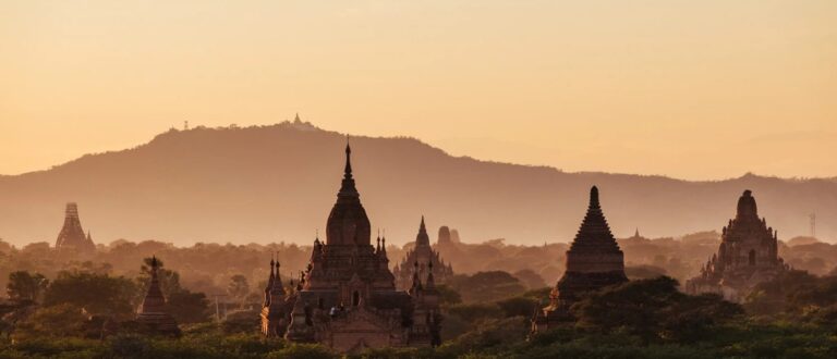
11. What are the main tourist attractions in Myanmar?
Popular attractions include Bagan’s ancient temples, Inle Lake, Mandalay, Yangon’s Shwedagon Pagoda, Ngapali Beach, and Kyaiktiyo Golden Rock Pagoda.
12. What is the population of Myanmar?
As of recent estimates, Myanmar has a population of approximately 55 million people, with the majority living in the central plains around the Ayeyarwady River.
13. What currency is used in Myanmar?
The official currency of Myanmar is the Kyat (MMK).
14. What is the climate like in Myanmar?
Myanmar has a tropical monsoon climate, with three main seasons: the hot season (March–May), the rainy season (June–October), and the cool season (November–February).
15. Why is Myanmar geopolitically important?
Myanmar’s location between India and China makes it a critical link between South and Southeast Asia. Its coastline along the Indian Ocean also provides strategic trade and energy routes.