
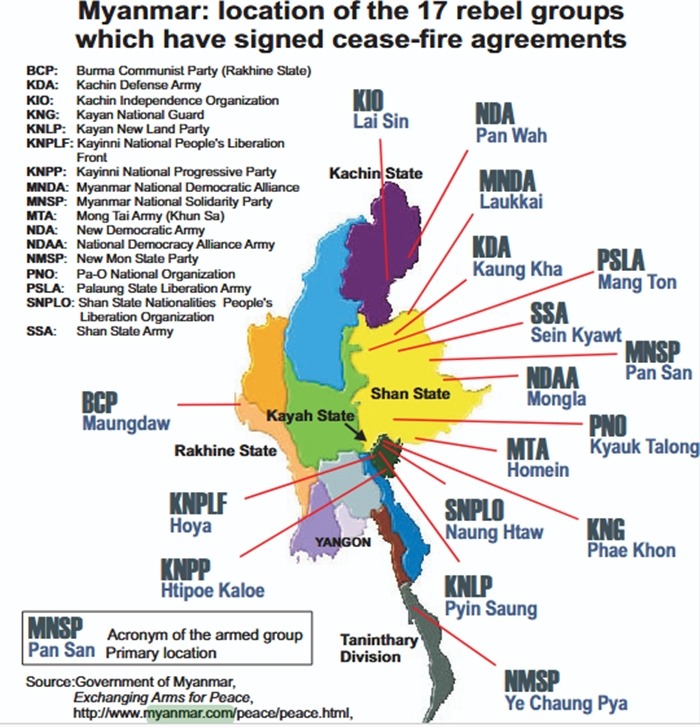
Myanmar’s 17 Cease-Fire Groups and Their Locations
For three decades, Myanmar’s conflict geography has been shaped by a patchwork of local cease-fires. The phrase “the 17 cease-fire groups” generally refers to the set of ethnic armed organizations (EAOs) that negotiated truces with the military government between 1989 and the late 2000s—long before the 2015 Nationwide Ceasefire Agreement (NCA) and the post-2021 nationwide war. These agreements varied in scope: some ushered in long lulls in fighting, others collapsed or morphed into militia/Border Guard Forces (BGFs). This guide locates those 17 groups on the map and explains how they fit into today’s landscape. Environmental Peacebuilding Association+1
Important note: locations below reflect each group’s core areas at/around the time of their cease-fire status (1990s–2010s). Some groups later transformed into BGFs, merged, or resumed hostilities. Where possible, up-to-date profiles are referenced. Myanmar Peace Monitor+1
The 17 cease-fire groups and their core locations
1) New Democratic Army–Kachin (NDA-K) — eastern Kachin State (Pangwa/Chipwi–China border). NDA-K signed in 1989; later converted into a BGF. Headquarters historically at Pangwa on the Kachin–China frontier. Wikipedia
2) Kachin Independence Organization/Army (KIO/KIA) — Kachin State (Laiza–China border). The KIO signed a 1994 cease-fire that broke down in 2011; its political/military HQ is Laiza on the Chinese border, and operations span much of Kachin. Wikipedia
3) Kayan National Guard (KNG) — Kayah (Karenni) State, Special Region 1. Signed a cease-fire in 1992; later transformed into a BGF as part of the 2009–2010 restructuring. Core area: northern/eastern Kayah. MIMU
4) Karenni National People’s Liberation Front (KNPLF) — Kayah State, Special Region 2 (Loikaw/nearby). Cease-fire in 1994; later became a BGF. Historic base areas around Loikaw and surrounding townships. (The group has since undergone further changes.) MIMU+1
5) Kayan New Land Party (KNLP) — southern Shan & Kayah frontier (Pekon/Demoso belt). KNLP’s centers include Seebu (Pekon Township) with activity across Demoso, Pekon, Pinlaung, and nearby areas straddling Shan–Kayah. Wikipedia
6) Democratic Karen Buddhist Army (DKBA) — Kayin (Karen) State, Thai border (Myawaddy–Hpa-An–Three Pagodas Pass corridor). DKBA split from the KNU in 1994 and entered cease-fire arrangements; influence stretched along the Thai border crossing zones and inland toward Hpa-An. Wikipedia
7) New Mon State Party (NMSP) — Mon State & Tanintharyi (Ye–Thanbyuzayat–Three Pagodas Pass–Yebyu). NMSP signed in 1995 (and later signed the NCA in 2018). Its strongholds historically hugged the Mon–Thai border and Mon coastal belt. Wikipedia
8) Myanmar National Democratic Alliance Army (MNDAA – Kokang) — Kokang Self-Administered Zone, northern Shan (Laukkaing/Laukkai). The first 1989 cease-fire group, rooted in Kokang along the China border; recent operations again center on Laukkaing and border gates. Wikipedia+1
9) United Wa State Army (UWSA) — Wa Self-Administered Division, eastern Shan (Pangkham/Mong Pawk). The largest EAO, based in Wa State along the China frontier, with HQ at Pangkham and depth across northern and southern Wa districts. Wikipedia+1
10) Shan State Army “North” / Shan State Progress Party (SSPP/SSA-N) — northern/eastern Shan (Wan Hai – Kehsi/Kyethi, Hsipaw–Kyaukme arc). The SSPP/SSA-N kept a cease-fire status for long periods; its HQ is Wan Hai in Kehsi Township with deployments across northern Shan. Wikipedia+1
11) National Democratic Alliance Army (NDAA – Mongla, “Special Region 4”) — eastern Shan (Mongla area). The Mongla group governs Eastern Shan State Special Region 4, bordering China; HQ at Mongla. Wikipedia+2Wikipedia+2
12) Kachin Defense Army (KDA / Kaungkha militia) — northern Shan (Kutkai/Kaungkha area). Originally a Kachin splinter that took cease-fire status, later converted to pro-Tatmadaw militia; operated in northern Shan rather than Kachin proper. Wikipedia
13) Pa-O National Army (PNA) — Pa-O Self-Administered Zone, southern Shan (Hopong–Hsi Hseng–Pinlaung). The PNA (and allied PNLO/PNLA later) anchor Pa-O areas along the southern Shan plateau and highways toward Loikaw/Taunggyi. Wikipedia+1
14) Palaung State Liberation Army (PSLA) — northern Shan (Namhsan/Tawngpeng uplands). A cease-fire entity that later dissolved; today’s Ta’ang/TNLA traces lineage to the PSLO/A and is based around Namhsan and broader Tawngpeng. Wikipedia+2Wikipedia+2
15) Shan State Nationalities People’s Liberation Organization (SSNPLO) — southern Shan (Mawkmai–Mong Hsu–Pekon belt). Cease-fire in 1994; later forced to surrender (2008). Its footprint lay in southern Shan between Loikaw approaches and central Shan hills. Wikipedia
16) Shan State National Army (SSNA) — northern/central Shan (Hsipaw/Kyaukme axis). Formed from MTA remnants; signed a 1995 cease-fire, with known bases near Hsipaw and deployments across northern Shan at its height. Wikipedia+1
17) Karenni National Progressive Party (KNPP) — Kayah State (Shadaw/Demoso/Loikaw hinterland). The KNPP’s 1995 cease-fire collapsed after about three months; nevertheless it is often included in “17 cease-fire groups” lists because it temporarily held that status before reverting to war. Scribd
Where this list comes from: an archived briefing circulated during the 2009–2010 Border Guard Force push enumerated “the 17 official cease-fire groups” by state (Kachin, Kayah/Karenni, Karen, Mon, Shan) and noted which later surrendered, merged, or transitioned into BGFs. We cross-reference those names with independent profiles for locations and headquarters. Scribd+2Transnational Institute+2
How the cease-fire map evolved after 2010
Three major shifts followed the “17” era:
BGF/ militia conversion: Several cease-fire groups transformed into Border Guard Forces under Tatmadaw command (e.g., NDA-K, KNPLF, KNG, parts of KDA), changing their status and, in some cases, their territories and allegiances. MIMU+1
The 2015 NCA: A separate framework brought new signatories—initially 8, later 10—such as the NMSP and Lahu Democratic Union (2018). Not all historic cease-fire groups joined the NCA, and key players (e.g., UWSA, MNDAA, SSPP/SSA-N) remained outside. Wikipedia
Post-2021 realignment: After the 2021 coup, fronts reopened and new alliances reshaped control, especially in northern Shan (MNDAA/TNLA/AA offensives around Laukkaing, Lashio, Kyaukme, Muse) and in Kachin. Even where older cease-fires once held, today’s battlefield looks very different. AP News+2Reuters+2
Reading the map today (state-by-state snapshots)
Kachin: Historic cease-fire actors included NDA-K (now BGF) along the Pangwa borderlands; KIO/KIA remains active from Laiza outward. Fighting surged again in 2023–2025 across Chipwi/Hsawlaw and Myitkyina approaches. Wikipedia+2Wikipedia+2
Kayah (Karenni): The KNG and KNPLF became BGFs; KNPP’s brief 1995 truce collapsed. The KNPP and allied Karenni forces operate across Loikaw–Demoso–Hpruso axes today. MIMU+1
Kayin (Karen): DKBA’s cease-fire footprint straddled Myawaddy–Hpa-An–Three Pagodas Pass. (Later years saw splinters/re-brandings and complex relations with the Tatmadaw and KNU.) Wikipedia
Mon & Tanintharyi: NMSP held areas in Ye/Thanbyuzayat corridors and toward Three Pagodas Pass; it eventually signed the NCA (2018). Wikipedia
Shan (North/East/South): This is the densest cluster: MNDAA (Kokang) at Laukkaing; UWSA in Wa State (Pangkham); NDAA (Mongla) in Special Region 4; SSPP/SSA-N at Wan Hai with wide deployments; PNA/Pa-O in Hopong–Hsi Hseng–Pinlaung; SSNA and SSNPLO (now defunct/merged) once dotted the Hsipaw–southern Shan belt; PSLA dissolved but its lineage continues as TNLA based around Namhsan/Tawngpeng. Recent campaigns repeatedly shifted control around Lashio, Kyaukme, Kutkai, Muse. Wikipedia+7Wikipedia+7Wikipedia+7
Why these locations mattered
Border economies and corridors: Many cease-fire zones sit on China or Thailand corridors—Kokang/Laukkaing, Wa State, Mongla (to Yunnan); Myawaddy/Three Pagodas (to Thailand). Control of gateways shaped both taxation/trade and the durability of truces. Wikipedia+1
Self-administered areas: The 2008 Constitution recognized Self-Administered Zones/Divisions (e.g., Pa-O, Kokang, Wa) that overlapped with cease-fire territories—formalizing local governance and cementing geography that grew from 1990s truces. Wikipedia+1
Cease-fire → BGF transitions: Where groups accepted BGF conversion, their forces remained locally embedded—but under Tatmadaw command—preserving some territorial influence even as political autonomy narrowed. MIMU+1
Glossary (quick IDs)
MNDAA (Kokang): Laukkaing/Mone Koe sector, China border. Wikipedia
UWSA (Wa State): Pangkham/Mong Pawk and southern Wa districts. Wikipedia
NDAA (Mongla, SR-4): Mongla, eastern Shan. Wikipedia
SSPP/SSA-N: Wan Hai (Kehsi), northern Shan. Wikipedia
PNA/Pa-O: Hopong–Hsi Hseng–Pinlaung, southern Shan. Wikipedia
PSLA (legacy)/TNLA (today): Namhsan/Tawngpeng uplands. Wikipedia+1
NDA-K: Pangwa sector, east Kachin (now BGF). Wikipedia
KIO/KIA: Laiza and wider Kachin. Wikipedia
DKBA: Myawaddy–Hpa-An–Three Pagodas Pass. Wikipedia
NMSP: Ye–Three Pagodas axis, Mon/Tanintharyi. Wikipedia
KNG / KNPLF / KNLP: Kayah and adjacent southern Shan townships (Demoso, Pekon, Pinlaung). MIMU+2Wikipedia+2
KDA (Kaungkha): Northern Shan (Kutkai belt). Wikipedia
SSNPLO / SSNA: Southern & northern Shan (Mawkmai/Mong Hsu; Hsipaw). (Defunct/merged). Wikipedia+1
KNPP: Kayah highlands around Loikaw/Shadaw (1995 truce collapsed). Scribd
How to present this on Myanmar.com
Create a state-by-state section with short capsules; link each capsule to a fuller profile page (e.g., “Wa State – UWSA”, “Kokang – MNDAA”).
Add a simple locator map with numbered pins: 1–17 matching the list above.
Include a historical timeline sidebar (1989–1995 first cease-fire wave; 2009–2010 BGF push; 2015 NCA; 2021-present realignment).
Use schema.org Article markup and internal links to your “Ethnic Groups,” “States & Regions,” and “Peace Process” hubs.
Sources & reliability
This article triangulates (1) an archival list enumerating “17 official cease-fire groups” circa the 2009–2010 BGF push, (2) independent organization profiles and state infographics for locations, and (3) reputable conflict analyses. For deeper reading: Myanmar Peace Monitor’s ERO profiles; Transnational Institute (TNI) reports on cease-fires; and background on the 2015 NCA. Wikipedia+4Scribd+4
For historical reference, see the original UNODC report on Myanmar (2001) .
Related posts:
 Kayah State: People, Culture, Traditions, and Heritage of Myanmar’s Smallest State
Kachin State People and Culture: History, Identity, and Traditions
Shan State: People, Culture, and Heritage of Myanmar’s Largest State
General Information on the Union of Myanmar
Christianity in Myanmar: Origins, Culture and Struggles
Kayah State: People, Culture, Traditions, and Heritage of Myanmar’s Smallest State
Kachin State People and Culture: History, Identity, and Traditions
Shan State: People, Culture, and Heritage of Myanmar’s Largest State
General Information on the Union of Myanmar
Christianity in Myanmar: Origins, Culture and Struggles
 Major General Twan Mrat Naing – Arakan Army Chief